Pre-Construction
Documentation
& Existing Conditions Documentation
We match any written specification your project requires — from CSI 01 32 33 to FDOT Section 108 to custom municipal engineering specs. Geotagged imagery, 4K video with telemetry overlays, professional voiceover narration, and indexed deliverables structured for legal defensibility and project submittal.
Documentation Built to
Any Specification
Your Project Requires
Most drone operators sell vague "existing conditions photos." We deliver structured documentation that maps directly to whatever specification your project contract references — whether that's CSI MasterFormat Section 01 32 33, FDOT Section 108, a municipal engineering spec, or a custom client requirement. We adapt our deliverables to satisfy the exact format, metadata, naming, overlay, and narration requirements your spec dictates.
We've successfully delivered to specifications originally written for ground-based vehicle documentation by working directly with the project engineer to translate requirements into aerial capture. From municipal wastewater plant expansions to FDOT right-of-way projects, we handle the spec interpretation so you don't have to — you get a compliant deliverable without the back-and-forth.
Per-Image Metadata We Capture
STANDARD METADATA FIELDS (CUSTOMIZABLE PER SPEC)
4K Video with Real-Time
Telemetry Overlays & Voiceover
Our documentation videos go beyond simple flyover footage. Every frame can include burned-in telemetry data that ties the visual record to a specific location, altitude, and moment in time — creating an immutable chain of evidence that satisfies the most demanding project specifications and legal requirements.
Telemetry Data Overlay
Real-time flight data burned directly into the video frame. Every second of footage is tied to verifiable positional data — making it impossible to dispute when or where the documentation was captured.
On-Screen Data Fields
Professional Voiceover Narration
Many project specifications require that pre-construction video include recorded audio narration describing all noted conditions. Our professional voiceover option satisfies these requirements while creating a more comprehensive and accessible record for stakeholders who may not be familiar with the site.
Narration Covers
Why a Documented Baseline
Protects Your Project
Construction disputes are expensive. A neighbor claims your earthwork changed their drainage. A subcontractor says conditions were different from what was represented. An adjacent property owner alleges vibration damage from your pile driving. Without a pre-construction baseline, you're defending against claims with nothing but your word.
Under Florida Statute Chapter 558, parties in a construction defect claim must exchange photographs and videos within 30 days of a pre-suit notice. Having a professional, spec-compliant baseline record means you're prepared before the first demand letter arrives — not scrambling to find phone photos that may or may not have timestamps.
Our documentation satisfies the "Stuyvesant test" for differing site conditions claims (both Type I and Type II) by providing objective, timestamped evidence of actual surface conditions at the time of contract. It also aligns with AIA A201-2017 requirements for documenting existing conditions before work begins.
Cost of Not Documenting
What's Included in Your
Pre-Construction Documentation
20MP Nadir & Oblique Aerials
High-resolution aerial stills captured from directly above (nadir) and at multiple oblique angles around the full site perimeter. Every image is geotagged, timestamped, and tied to a numbered key plan.
4K Documentation Video
Cinematic 4K video flyover documenting the complete site, adjacent properties, and existing infrastructure. Available with telemetry overlays and professional voiceover narration.
Telemetry Data Overlays
Real-time on-screen display of drone altitude (AGL), GPS coordinates, compass heading, date/time, and custom text fields — burned into the video for an immutable visual record.
Professional Voiceover
Optional narrated documentation describing observed conditions, drone position and heading, areas of concern, adjacent property features, and elements relevant to project scope — satisfying spec narration requirements.
Orthomosaic Baseline Map
High-resolution 2D orthomosaic map stitched from hundreds of overlapping aerial images. Georeferenced GeoTIFF output compatible with AutoCAD, Civil 3D, and ArcGIS for precise site measurement.
Indexed Photo Log & Key Plan
Every image is sequentially numbered and keyed to a site plan showing exact vantage point, compass direction, and elevation. Submittal-ready PDF package with cloud delivery link.
GPS & Metadata Preservation
All files retain unaltered EXIF metadata including GPS coordinates, altitude, date/time, and camera settings. No cropping, no editing — original files preserved for legal defensibility.
Flexible Turnaround
Flexible delivery to meet your schedule. Tell us when you need it flown and when you need it delivered — we'll make sure it's ready. Includes cloud folder access, optional USB delivery, and submittal-ready documentation for immediate distribution.
What Makes Documentation
"Defensible" in Court
Not all site photos are created equal. Here's what separates a defensible baseline record from a folder of random images that won't hold up under legal scrutiny.
Unaltered Originals
No editing, no cropping, no manipulation. Original sensor data preserved exactly as captured. Any alteration destroys legal admissibility.
Embedded Timestamps
Date and time recorded in EXIF metadata at the moment of capture — not added after the fact. Verifiable against flight log records.
GPS Geotags
Every image tied to precise latitude/longitude coordinates. Proves exactly where the camera was pointed and eliminates location disputes.
Systematic Coverage
Complete, methodical documentation of the entire site — not cherry-picked angles. A key plan proves nothing was intentionally omitted.
Sequential Indexing
Every file numbered sequentially and keyed to a site plan. Creates a clear, auditable chain that shows completeness and order.
Chain of Custody
Flight logs, raw imagery, and delivery records retained for 3+ years. Clear documentation of who captured, processed, and delivered the files.
Pre-Construction Documentation
for Every Project Type
Commercial Construction
Retail centers, office parks, warehouses, and mixed-use developments along the I-75 corridor. Document pad sites, parking areas, and utility corridors before earthwork mobilization.
Residential Subdivisions
Multi-lot developments from clearing through vertical construction. Document drainage patterns, tree lines, adjacent lot conditions, and shared infrastructure before the first stake is driven.
Roadway & Utility / ROW Work
FDOT and municipal right-of-way projects, haul routes, and utility corridor installations. Document existing pavement conditions, drainage structures, and adjacent properties within spec-defined radii.
Deep Foundation & Pile Driving
Adjacent-property documentation before vibration-intensive operations. FDOT Section 108-2.1.2 requires condition inspection within 200 ft of sheet pile and 100 ft of soldier pile operations.
Demolition & Infill
Document adjacent building conditions, shared walls, street-level infrastructure, and neighboring structures before demolition or excavation in tight urban sites.
Municipal & Public Works
Wastewater treatment plant expansions, water reclamation facilities, pump stations, and public infrastructure upgrades. We work directly with the project engineer to satisfy municipal specifications — including those originally written for ground-based documentation methods.
FAA-Certified, Insured &
Submittal-Ready
FAA Part 107 Certified
All pilots hold current FAA Part 107 Remote Pilot Certificates with active medical clearance. We handle all LAANC airspace authorizations for controlled airspace near OCF, GNV, and other local airports.
$2M+ Aviation Liability
Separate aviation liability policy (not standard GL) specifically covering commercial drone operations on active construction sites. Additional-insured endorsement and COI available on request.
Retained Flight Logs
Complete flight telemetry data retained for 3+ years — including GPS tracks, altitude profiles, timestamps, and pilot notes. Supports chain-of-custody requirements for legal proceedings.
Submittal-Ready Packages
Deliverables formatted for immediate project submittal: indexed photo logs, key plans, sequential naming, and organized folder structures that satisfy architect and CM review requirements.
Municipal Wastewater Treatment
Plant Expansion
A real-world example of spec-compliant pre-construction documentation for a public-works project with a formal technical specification originally written for ground-based documentation methods.
The Challenge
A general contractor working on a municipal wastewater treatment plant expansion needed pre-construction documentation that satisfied a formal written specification. The spec dictated exact requirements for on-screen overlays, recorded audio narration, timestamp verification, and specific text fields — but it was originally written for ground-level vehicle-based documentation methods, not aerial capture.
Our Approach
We worked directly with the project engineer to translate ground-based documentation requirements into aerial capture methodology. We clarified ambiguous spec language (station numbers, viewing side, direction of travel), resolved document inconsistencies, and adapted overlay placement to match the spec's intent while leveraging the superior coverage of aerial documentation.
The Result
Delivered a ~15-minute aerial documentation video with continuous on-screen overlays (date/time from drone telemetry, project name, contract number, site address), professional voiceover narration describing all observed conditions, plus high-resolution still photography — all organized and labeled per the client's specification requirements.
What Was Delivered
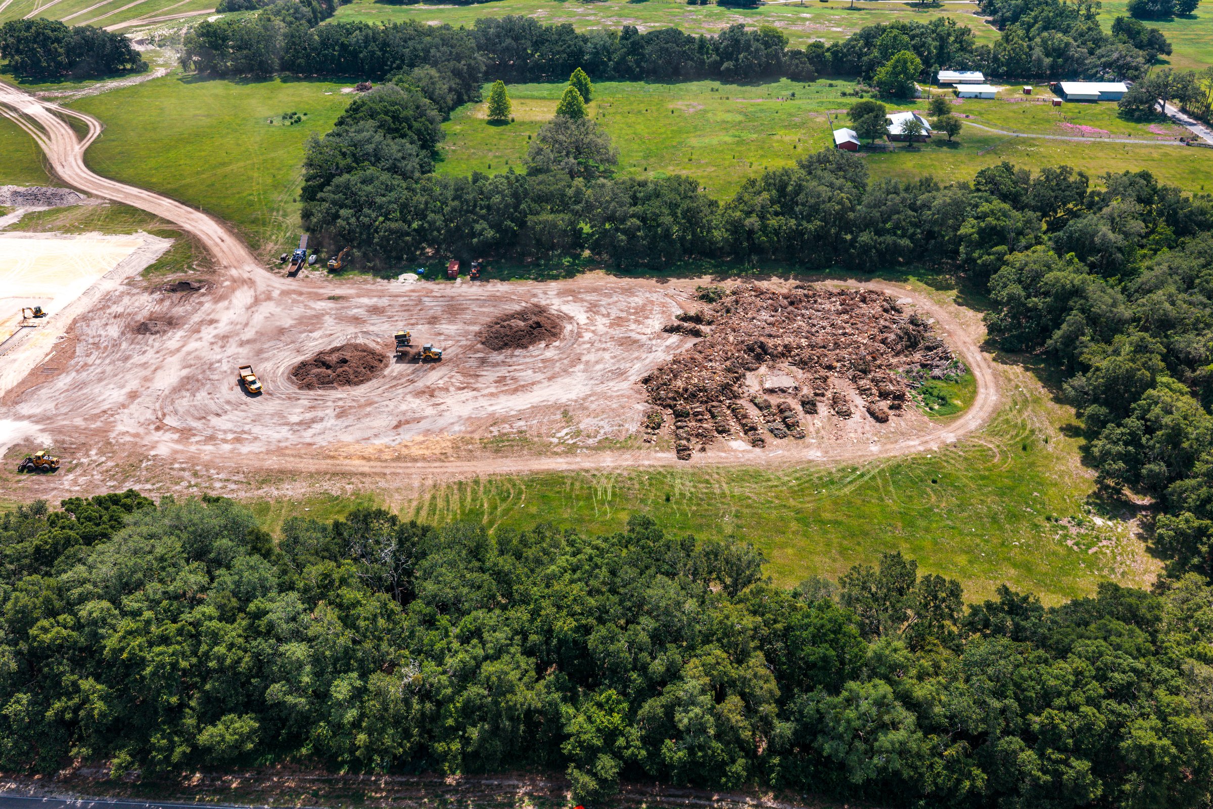
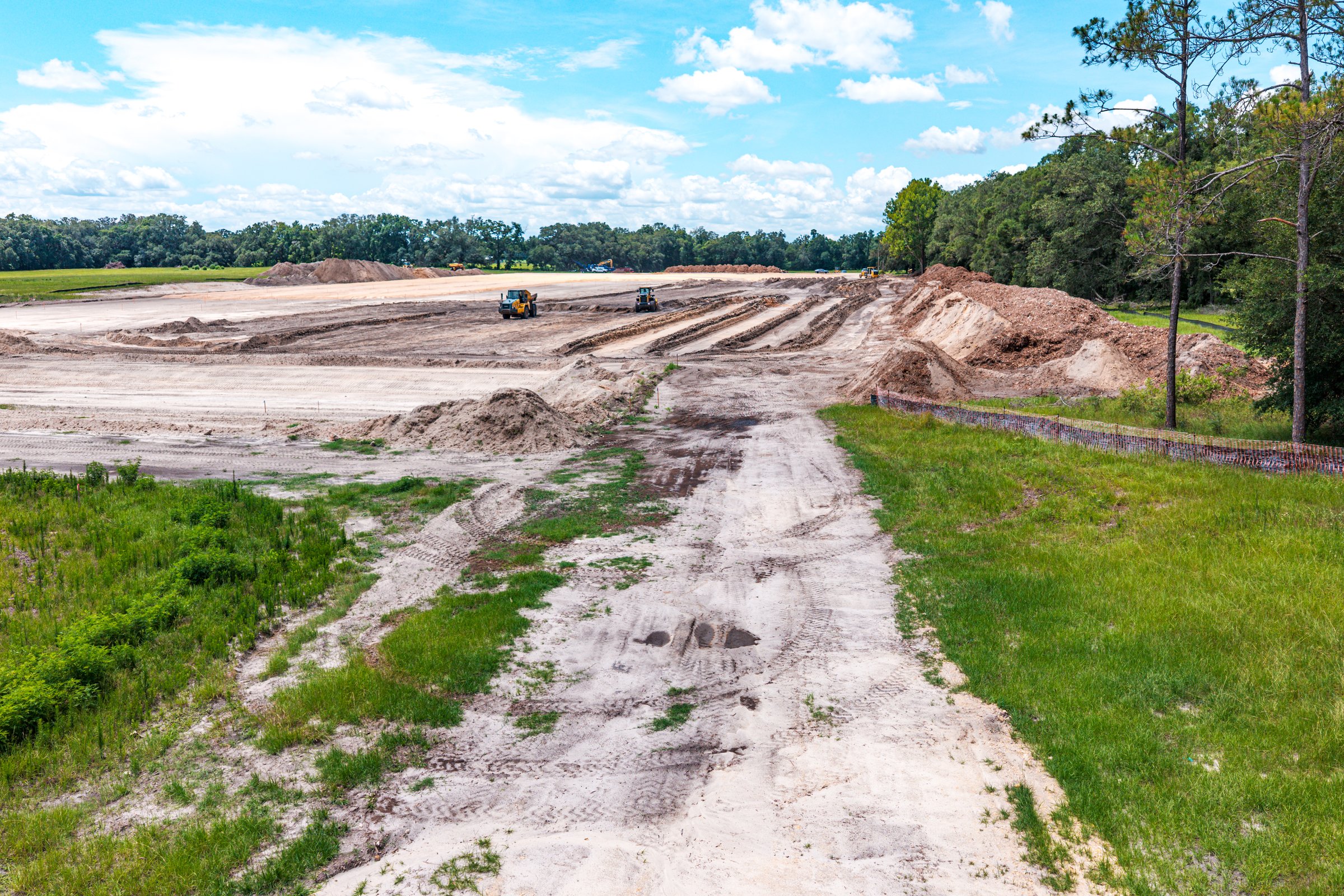
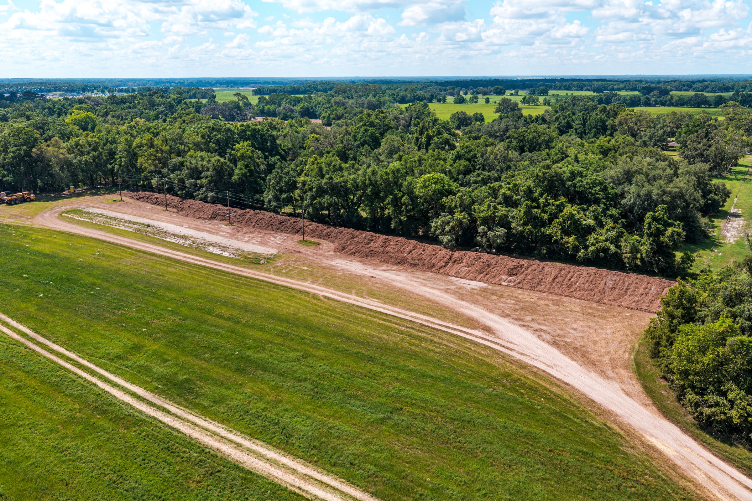
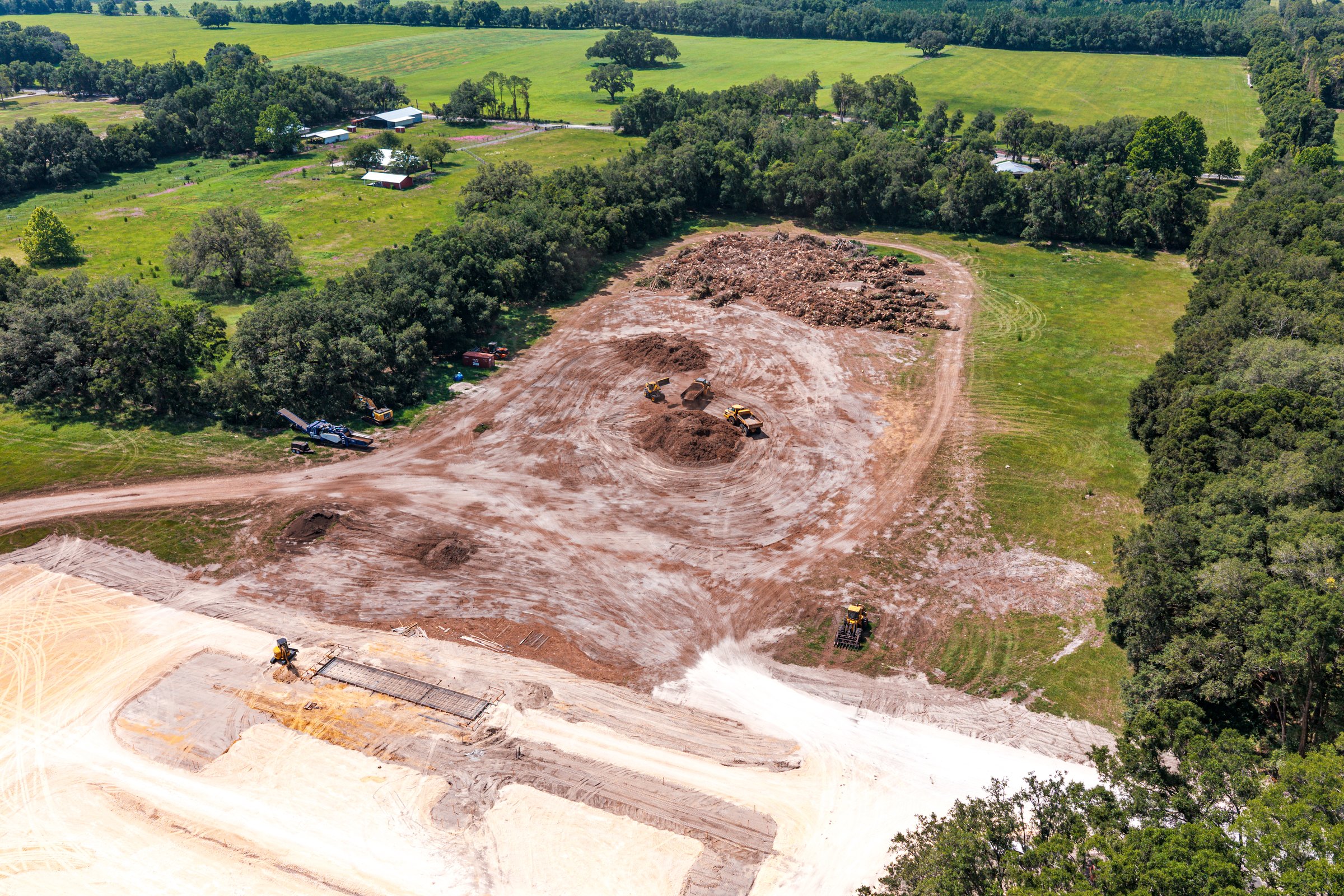
Project Photos — Newberry WWTP Expansion
Adjacent property boundary & existing drainage swale — pre-disturbance
Site clearing in progress — equipment positions documented
Full site overview — vegetation removal & earthwork staging
Active grading — sediment barrier and erosion control documented
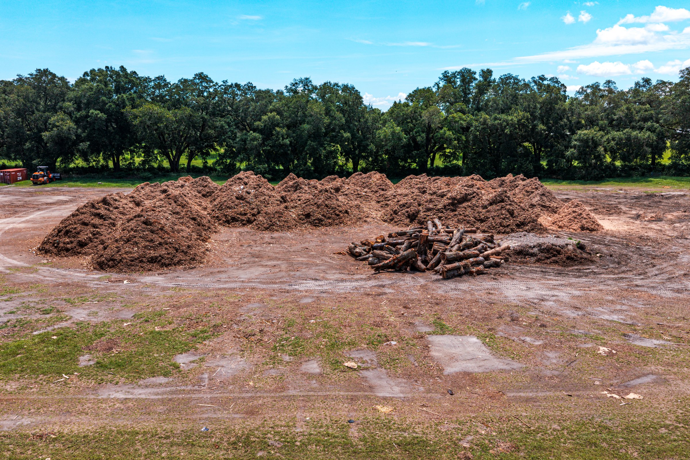
Cleared pad — mulch stockpile and site access road
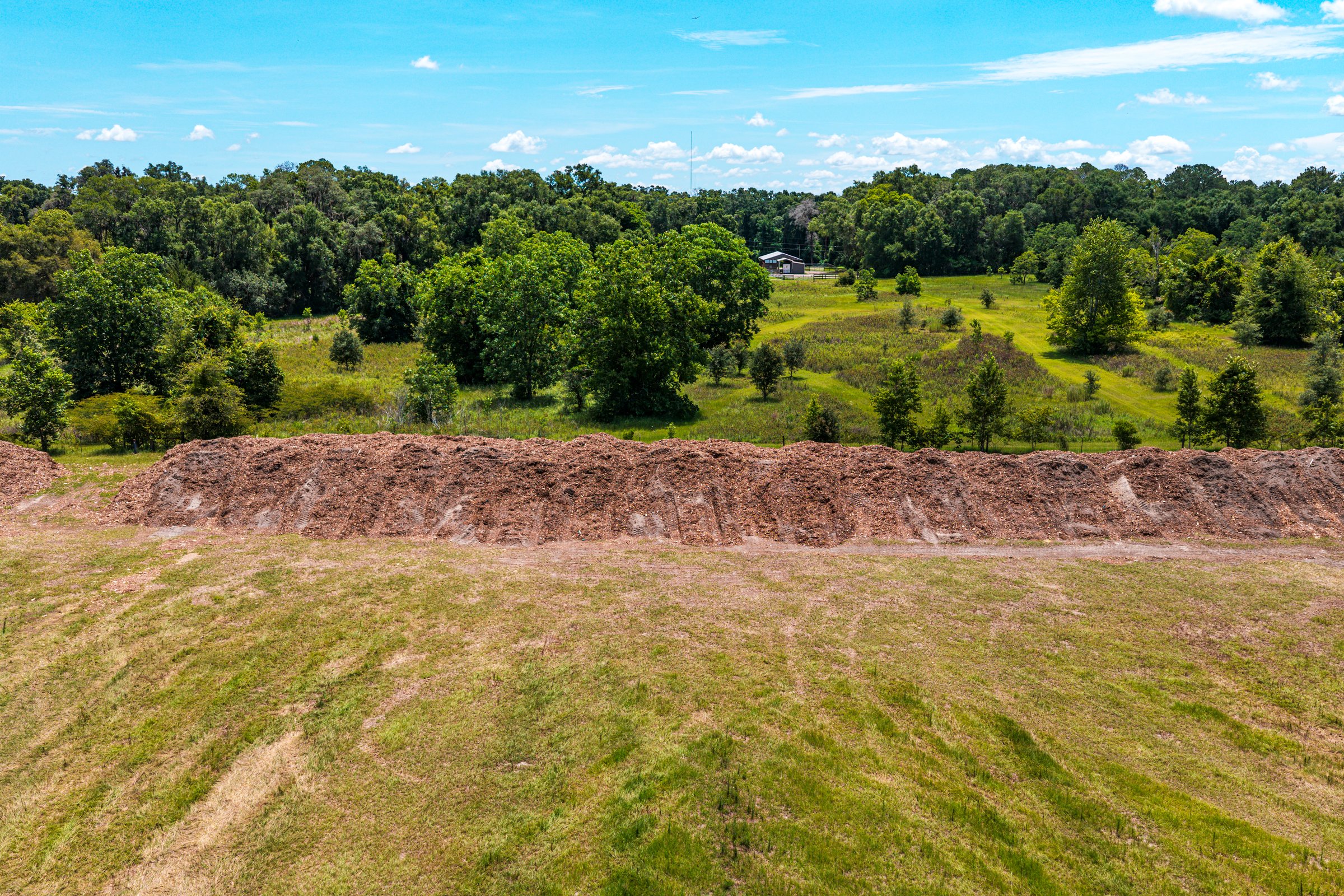
Perimeter documentation — adjacent parcels and tree line
▸ 20MP aerial stills — 6144×4096px native resolution — Newberry, FL
Why This Matters for Your Project
This project demonstrated that spec-compliant aerial documentation requires more than just flying a drone and pressing record. It requires understanding the spec's intent, working with the project engineer to resolve ambiguities, and delivering a product that satisfies the letter and spirit of the requirement — even when the spec was never written with aerial capture in mind.
Pre-Construction Documentation
Packages
Standard Documentation
Single-lot or small commercial site up to 5 acres
Best for: Residential infill, small commercial pads, neighbor dispute prevention
- Single flight session
- 20MP nadir & oblique aerial photo set
- 4K documentation video
- Geotagged & timestamped files
- Indexed photo log with key plan
- Flexible delivery — we work around your schedule
Extended Documentation
Multi-acre sites, subdivisions, and commercial developments
Best for: Subdivisions, FDOT projects, lender requirements, legal protection
- Multi-flight session for full coverage
- 20MP nadir & oblique aerial photo set
- 4K video with telemetry overlays
- Professional voiceover narration
- Adjacent property documentation
- Indexed photo log with key plan
- Submittal-ready PDF package
- Flexible delivery — we work around your schedule
Documentation + Mapping
Full documentation plus georeferenced orthomosaic baseline
Best for: Large sites needing both visual and measurable baseline records
- Full extended documentation package
- 4K video with overlays + voiceover
- 2D orthomosaic baseline map
- Georeferenced GeoTIFF output
- CAD/GIS compatible deliverables
- Complete submittal package
Start With Pre-Con Documentation,
Then Keep Documenting Through Final Inspection
The most comprehensive project documentation starts before ground breaks and continues through certificate of occupancy. Pair your pre-construction baseline with weekly or bi-weekly progress monitoring for an unbroken visual record — from existing conditions through ribbon-cutting. Same pilot, same angles, same deliverable format.
Pre-Construction Documentation
Questions
Pre-construction documentation is a systematic, spec-compliant record of existing site conditions captured before any ground disturbance begins. Unlike a handful of phone photos, our documentation is structured to match whatever specification your project requires — every image is geotagged, timestamped, sequentially indexed, tied to a key plan, and delivered in an unaltered format that holds up in court. It's the difference between 'we took some pictures' and 'we have a defensible baseline record.'
We specialize in matching any and all written specifications your project contract requires. Whether it's CSI MasterFormat Section 01 32 33, FDOT Section 108, a municipal engineering spec written for ground-based documentation methods, or a custom client requirement — we adapt our deliverables to satisfy the exact format, metadata, naming, overlay, and narration requirements your spec dictates. We've successfully delivered to specs originally written for vehicle-based methods by working directly with the project engineer to translate requirements into aerial capture.
Our 4K documentation videos can include real-time telemetry overlays showing drone altitude (AGL), GPS coordinates, compass heading, date/time stamp, ground speed, and custom text fields such as project name, contract/P.O. number, site address, contractor name, and flight number. All timestamps are pulled from actual drone telemetry metadata — not decorative graphics — so every frame is tied to a verifiable moment in time. Overlay placement and content are fully customizable to match your client's written specification.
Yes. Professional voiceover narration is available for any documentation video. The narrator describes observed site conditions, the drone's position and heading, notes areas of concern, identifies adjacent property features, and calls out specific elements relevant to the project scope. Many municipal and public-works specifications require recorded audio narration describing all noted conditions — our voiceover satisfies these requirements while creating a more accessible record for stakeholders who may not be familiar with the site.
When a neighbor claims your project caused drainage damage, cracked their foundation, or disturbed their landscaping, your pre-construction documentation provides timestamped, geotagged evidence of exactly what those conditions looked like before your crew arrived. Under Florida Statute Chapter 558, parties must exchange photographs and videos within 30 days of a pre-suit notice — having a professional baseline record means you're prepared from day one.
Type I conditions differ from what was indicated in the contract documents (e.g., rock where soil was shown). Type II conditions are unusual and differ from what would normally be expected (e.g., unexpected underground utilities). Both can trigger costly change orders. A pre-construction aerial baseline documents actual surface conditions at the time of contract, providing objective evidence for differing-site-conditions claims under AIA A201-2017.
We recommend booking 5–7 business days before your groundbreaking date to allow time for FAA airspace authorization (LAANC) and flight planning. For projects near controlled airspace — such as Ocala International Airport (OCF) or Gainesville Regional (GNV) — we handle all authorizations at no additional cost. Rush bookings may be available for urgent mobilizations.
All imagery is delivered as unaltered JPEG or TIFF originals with embedded EXIF metadata (GPS, date/time, camera settings). Files follow sequential naming (001–999) with project identifiers per CSI 01 32 33 requirements. Video is delivered as 4K MP4 (H.265). The complete package includes a key plan PDF, indexed photo log, and organized folder structure ready for project submittal or legal discovery.
Yes — we serve all of North Central Florida including Gainesville, Wildwood, The Villages, Belleview, Spring Hill, Crystal River, Leesburg, Clermont, Brooksville, Dunnellon, Newberry, and Lady Lake. We cover 6 counties and 13 cities across the 352 area code.
Yes. Our documentation is specifically structured for legal defensibility: unaltered original files, embedded metadata, sequential indexing, key plan references, and retained flight logs create a clear chain of custody. This format satisfies Florida Rules of Evidence requirements for photographic evidence and has been used successfully in construction dispute resolution, insurance claims, and Chapter 558 pre-suit proceedings.
Document Before You Disturb
Book at least 5–7 business days before your first scheduled site activity. We handle all FAA airspace authorizations at no additional cost. Serving all of North Central Florida — 6 counties, 13 cities.
Pre-Construction Documentation Available Near You
Ocala
Marion County pre-construction documentation for residential and commercial projects.
Gainesville
Alachua County baseline documentation for UF-area and I-75 corridor development.
Wildwood
I-75 logistics corridor and Sumter County pre-construction documentation.
Belleview
South Marion County documentation for rural and residential projects.
The Villages
Sumter County community expansion pre-construction documentation.
Spring Hill
Hernando County SR-52 corridor baseline documentation.
Crystal River
Citrus County coastal and industrial pre-construction documentation.
Leesburg
Lake County US-27 corridor documentation services.
Clermont
Lake County Wellness Way corridor pre-construction documentation.
Brooksville
Hernando County civic and commercial documentation.
Dunnellon
Marion/Levy border pre-construction documentation.
Newberry
Alachua County I-75 corridor baseline documentation.
Lady Lake
Lake County Villages-adjacent pre-construction documentation.