37+ Drone Site Visits
Documenting Mobile Home Park Construction
Coquina Crossing — Elkton, FL
Monthly construction progress drone photography near St. Augustine, FL — documenting the expansion of a 55+ manufactured home community from land clearing to finished homesites. Photos and 4K video, every month, for 37 months and counting.
Drone Construction Site Documentation
in St. Johns County
Coquina Crossing is an established 55+ manufactured home community in Elkton, Florida — minutes west of St. Augustine in one of the fastest-growing counties in the state. As the community expands onto adjacent land, the developer needed something most vendors can't deliver: a documentation partner who would show up every single month, for years, and build a continuous visual record of the entire land development process.
That's exactly what this engagement is. Every month for 37 consecutive months — and counting — our FAA-licensed drone pilots have flown the Coquina Crossing expansion and delivered a full set of aerial photos and 4K video. The archive now spans every phase of residential land development site work: clearing and grubbing, stormwater pond excavation, mass grading, underground utility installation, and fine grading of finished homesites.
For a phased community expansion built alongside occupied streets, that continuous record does real work: it verifies contractor progress month over month, documents conditions before they're buried or paved, and gives ownership a stakeholder-ready visual story of the project — without anyone leaving their desk. It's recurring drone site documentation working the way it's supposed to: quietly, reliably, and without a single missed month.
Project Specifications
| Project Type | 55+ Community Expansion — Land Development |
| Community | Coquina Crossing |
| Location | Elkton, FL — St. Johns County (St. Augustine area) |
| Documentation Began | Mid-2023 |
| Status | Ongoing |
| Total Visits | 37+ and counting |
| Flight Cadence | Monthly |
| Deliverables | Aerial photos + 4K video, every visit |
| Reliability | 37/37 on-time deliveries |
From Raw Woods to Finished Homesites —
Mobile Home Park Construction, Month by Month
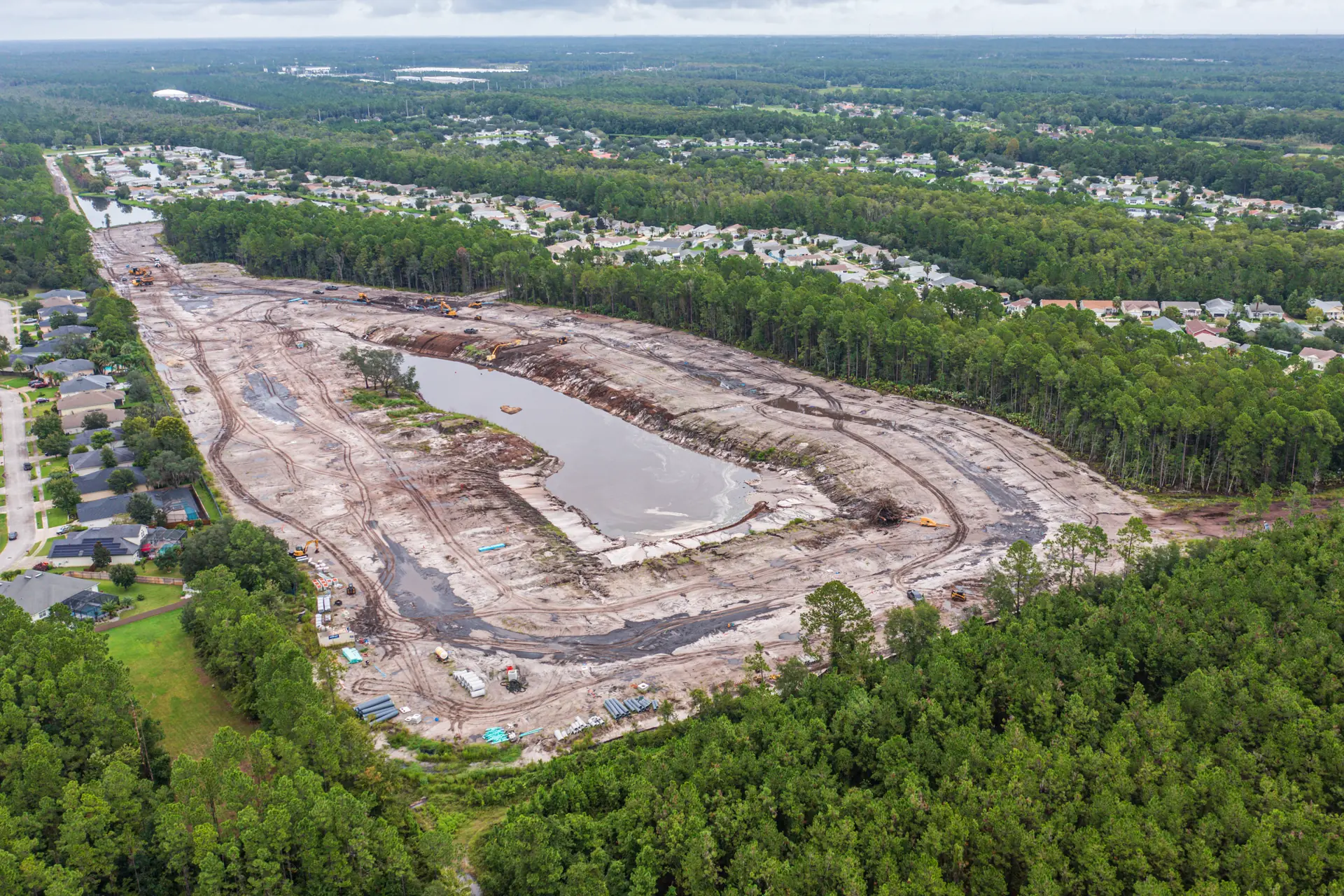
Across 37 months, monthly flights have captured every phase of the expansion. Two of the most documentation-critical phases are shown here — stormwater and underground utilities — each captured from the air as the work happened.
Inside the 37-Month
Aerial Archive
A selection from the monthly archive — stormwater pond excavation, mass grading, and underground utility installation, photographed as the work happened. The full archive belongs to the client; these frames show the range of what a recurring program captures.
Why Multi-Year Land Development
Needs a Continuous Aerial Record
A manufactured home community expansion isn't a building project with a start and a finish — it's a land development program that unfolds in phases over years, often directly beside streets where residents already live. Sequencing is driven by stormwater: ponds and swales have to work before pads can be certified, and utility mains have to be in the ground before the first new home is set. Most of that work is invisible within weeks of being finished. The pond banks grass over, the trenches are backfilled, the pads get homes — and without a continuous record, the construction history of the site simply disappears.
That's the case for monthly aerial documentation on 55+ community expansion and residential land development site work: it preserves the site's history while it can still be seen. When a drainage question, a warranty claim, or a utility locate comes up in year four, the answer isn't in anyone's memory — it's in the archive, timestamped and geotagged, one folder per month, going back to the first cleared acre. This engagement runs alongside our other recurring programs, including 34 consecutive on-time bi-weekly visits at Averitt's Ocala service center and the 39-visit Old Dominion terminal record in Wildwood — the same discipline, applied to a different kind of project.
Monthly Drone Progress Photos
and 4K Video — Every Single Visit
A recurring documentation program is only as useful as what lands in the client's inbox each month. Every Coquina Crossing visit produces two deliverable types, organized and delivered on schedule.
High-Resolution Aerial Photos
Each monthly flight captures the full expansion area — overview frames that show the whole site in context, and closer frames that document specific work fronts: pond banks, utility trenches, pipe staging areas, and homesite pads. Every image is timestamped and geotagged, which is what turns a nice photo into usable documentation. Photos are the workhorse deliverable for manufactured home community development: they drop straight into owner reports, lender packages, and marketing updates.
4K Aerial Video
Video does what stills can't: it carries a viewer across the site in a single continuous pass, showing how the phases connect — where the new streets meet the existing community, how the stormwater system ties together, how much ground the project actually covers. For stakeholders who have never walked the site, sixty seconds of 4K aerial video communicates more than a folder of photos. Over 37 months, the video archive has become a month-by-month motion record of the entire expansion.
How a 37-Month Program
Stays Reliable
Long engagements don't survive on enthusiasm. They survive on process — the same four habits, repeated every month for over three years.
Fixed Monthly Calendar
Flights are scheduled for the life of the project, not booked visit by visit. Weather windows are managed inside the month so the cadence never breaks.
Full-Site Coverage
Every visit captures overview frames of the whole expansion plus working frames of the active fronts — ponds, trenches, pads — so nothing depends on guessing what mattered.
Timestamped & Geotagged
Every image carries intact metadata. When the archive is asked a question years later, the answer comes with a date, a time, and coordinates.
Organized Delivery
One folder per visit, consistently named, delivered on schedule. A 37-month archive is only useful if the month you need is easy to find.
37 Visits. 37 On-Time Deliveries.
And Counting.
Anyone can fly a site once. The question a project manager should ask any drone vendor is simpler and harder: will you still be showing up, on schedule, in year three? At Coquina Crossing the answer has been yes for 37 consecutive months — through Florida summers, hurricane seasons, holiday weeks, and every phase of an active land development site.
That consistency is the product. A monthly archive with missing months has holes exactly where disputes and draw questions tend to land. A complete one answers questions before they're asked — which is why recurring drone site visits only create value when the operator treats the schedule as non-negotiable. We do.
Monthly Drone Progress
Documentation FAQ
It depends on how fast the site changes and who consumes the record. Vertical construction with weekly milestones often justifies weekly or bi-weekly flights; land development and sitework — clearing, earthwork, utilities, grading — typically moves at a pace where monthly drone progress photos capture every meaningful change at a fraction of the cost. Coquina Crossing runs on a monthly cadence, and 37 consecutive months of photos and video have captured every phase transition on the project. The right answer is the cadence you can sustain for the whole project: a documentation program only works if the record has no gaps.
Market rates for recurring construction drone photography in Florida typically run a few hundred dollars per visit for standard sites, with large or complex sites running higher. Pricing depends on site acreage, deliverables (photos only vs. photos plus 4K video), and airspace requirements — we don't charge travel fees, regardless of where your site is. Recurring monthly programs are usually priced below one-off shoots on a per-visit basis because the flight plan, site access, and delivery workflow are already established. Contact us for a quote on your specific site — recurring engagements are our specialty.
Three big ones. First, stakeholder communication: a monthly aerial photo set lets owners, investors, and lenders verify progress without a site visit — especially valuable for out-of-state stakeholders. Second, protection: timestamped aerial photos are objective evidence for pay application reviews, schedule discussions, and scope questions. Third, institutional memory: on a multi-year project like Coquina Crossing, the archive shows exactly what the site looked like at any month — including conditions that have since been buried, paved, or built over.
Yes — this is one of the most common reasons developers start a recurring documentation program. Timestamped, geotagged aerial photos establish what work existed on a given date: how much fill was placed, which utility runs were in the ground, what adjacent properties looked like before work began. A monthly archive means no dispute ever comes down to memory versus memory. We deliver every image with intact metadata so the record holds up under scrutiny.
Evaluate four things. FAA Part 107 certification and aviation insurance are the table stakes — ask for the certificate and a COI. Then ask about reliability: what percentage of scheduled visits has the operator actually delivered, on time, across their longest engagement? (Ours is 37 of 37 on this project.) Then look at deliverable organization — consistent naming, cloud delivery, intact metadata. Finally, confirm they can commit to your full project duration, not just the first few months. A documentation program with gaps in it loses most of its value.
Yes. Coquina Crossing — in Elkton, minutes from St. Augustine — has been on our monthly flight schedule for over three years. We're based in Gainesville and serve recurring engagements throughout Northeast Florida, including St. Augustine, St. Johns County, and the Jacksonville area, alongside our North Central Florida core service area. There are no travel fees — your site gets flown on schedule regardless of where it sits in our coverage area.
Yes — RV park and mobile home park site development is a natural fit for recurring aerial documentation, and Coquina Crossing is our longest-running example. These projects are horizontal land development: clearing, stormwater ponds, underground utilities, and pad construction spread across large acreage, usually phased over years and often adjacent to occupied homes. A monthly aerial record captures each phase before it's buried or built over, gives the community operator clean imagery for resident and investor communication, and documents conditions along the boundary with existing residents — the area where questions most often come up.
Yes. Because the archive spans the entire project — clearing, earthwork, utilities, grading — the visits can be sequenced into a time-lapse video showing the site's transformation from raw woods to finished homesites. Vantage points vary across a long archive like this one, so the result is a chronological montage rather than a fixed-camera time-lapse; for fixed-frame comparisons we can also program GPS waypoint missions going forward on any active project. Ask about time-lapse assembly when setting up a recurring program.
Services & Case Studies
Set Up Monthly Drone
Progress Photos for Your Site
Community expansion, residential subdivision, RV park or mobile home park site development, commercial sitework — if your project runs for months or years, a recurring aerial record is the cheapest insurance you'll buy. We fly monthly programs across Northeast and North Central Florida, from St. Augustine and Jacksonville to Ocala and Gainesville.